Tools & Technology: Instrument Towers
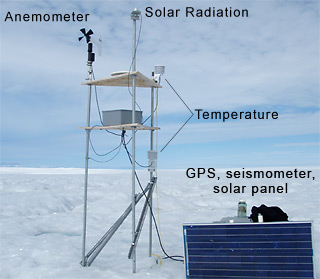
Most of the instruments the researchers use in Greenland—GPS, seismometers, and weather stations—are placed on small platforms constructed in the field.
GPS, or Global Positioning System, is a network of satellites that enables a GPS receiver to determine its location (latitude, longitude, and altitude), direction, speed, and time. This is the same system that airplane pilots, hikers, and some automobile drivers use for directions (although the receivers the scientists use are more accurate). Researchers in Greenland have placed GPS receivers and batteries into watertight boxes on the surface of the ice sheet. This tells them where the surface of the ice sheet is moving, and how fast it is traveling, over several years.
Seismometers are devices that can detect tiny vibrations and movements in the earth, similar to the way microphones detect vibrations from sound in the air. Although they are normally used to “listen” for earthquakes, they can also be used to detect movements in ice, called “icequakes.” When a glacial lake drains to the bottom of the ice sheet, the water flows down a crack. The seismometer can record the vibrations felt through the ice as it cracks open. Using the data from seismometers, researchers can identify exactly when the cracks open on the glacier. Together with the pressure transducer measurements, researchers can put together an accurate picture of how the lakes on the surface of the glacier are draining.
Weather stations record air temperature, wind speed and direction, and solar radiation. It is important for researchers to know as much as possible about the environment they study, especially when they can’t be there in person. Weather stations help answer questions like, when do the strongest winds blow? When is the air temperature the coldest?
All of these instruments record their data over an entire year and store it until the researchers return for data collection.
[ back ]


